Geo - informatics Assistant / GIS Technician
Entry Level Qualification
Class 12
Career Fields
Information Technology & Computer Science
For Specially Abled


Career Entrance Exam
About Career
Your work as a Geo-informatics Assistant / GIS Technician will mainly include installing, operating and collecting data through GIS (Geographic Information System) and analyzing that data. GIS is a network of specific locations and geographic data collected through satellites. This huge volume of geographical data is stored for future use in large digital databases through GIS software. You will be capturing, storing, manipulating and analyzing this spatial or geographic data.
You will calculate position/measure locations, download data and process the downloaded data with GIS software. You may need to install Windows and related GIS software in computer systems, create/develop databases, enter data into GIS databases or explore various websites with GIS content. You may also do field surveys for locating ‘assets’ like schools, hospitals, government offices, historical sites, roads, rails, canals, electric/telephone lines etc. using different GPS tools.
Key Roles and Responsibilities:
As a Geo-informatics Assistant / GIS Technician, you will be engaged with one or more of the following roles and responsibilities: -
Installing Windows and related GIS software on computer systems.
1. Downloading free satellite data and collecting information available at open source websites or from specific agencies and trusted sources.
2. Compiling data needed for map making like notes, photos, records etc.
3. Creating, developing, updating and maintaining Geo-databases and other databases for GIS data storage.
4. Using popular GIS software like AutoCAD Map 3D, ESRI ArcGIS, Landworks GIS, Maptitude, ILWIS Integrated Land and Water Information System), Geomaticaetc.
5. Applying standard mathematical formulas to identify and measure elevations, geographic locations etc.
6. Assigning addresses for new construction projects and performing field verifications of existing addresses.
7. Loading or transferring GIS data between different systems.
8. Doing field surveys to collect ground data for various GIS projects such as Forestry, Land use, Farming, Property tax, Irrigation.
PARTICULARS | DESCRIPTION |
Name | Geo - informatics Assistant / GIS Technician |
Purpose | Analyzing Geographic Data |
Career Field | Information Technology & Computer Science |
Required Entrance Exam | CUET UG, TRIPURA JEE |
Average Salary | 120000 - 200000 Rs. Per Year |
Companies For You | Capgemini, DSM Soft & Many More |
Who is Eligible | Class 12th Pass |
Career Entry Pathway
Class 10 all subjects as per scheme of studies - Class 11-12 with Mathematics & any other subject as per scheme of studies – Cartography Technician Course / Similar Course
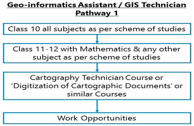
After Class 11-12, you can go for a Cartography Technician Course or ‘Digitization of Cartographic Documents’ or similar Courses.
Class 10 all subjects as per scheme of studies - Class 11-12 with Mathematics & any other subject as per scheme of studies – NSQF Level 5 Certificate for ‘Geo-Informatics Assistant’
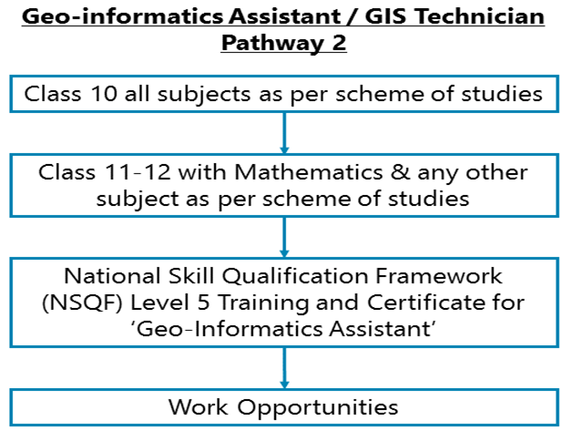
After Class 11-12, you can go for National Skill Qualification Framework (NSQF) Level 5Training and Certificate for ‘Geo-Informatics Assistant’. The total number of training hours is 2080 (1-year course) including Professional Skill Training, Professional Knowledge and Employability Skills Development, Library & Extracurricular activities, Project work/ Internship, and terminal Examination.
Class 10 all subjects as per scheme of studies - Class 11-12 with Mathematics (optional) & any other subject as per scheme of studies – Basic course in Photogrammetric Operator – Course in Digital Photogrammetry & Remote Sensing or similar course
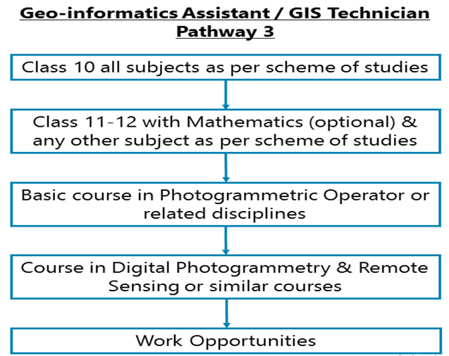
After Class 11-12, you can go for a basic course in Photogrammetric Operator or related disciplines, followed by a course in Digital Photogrammetry & Remote Sensing or similar courses.
Required Qualification & Competencies
After Class 10, then Class 11-12 with or without Mathematics & any other subject as per scheme of studies, you can do NSQF or other training programs.
Various private/public vocational training establishments across India offer related courses on:
1. Geographic Information Systems
2. GIS and Geo informatics
3. Remote Sensing & GIS
4. Geospatial and Geographic Information Systems
5. GIS Consultant
6. GIS Technical Assistant
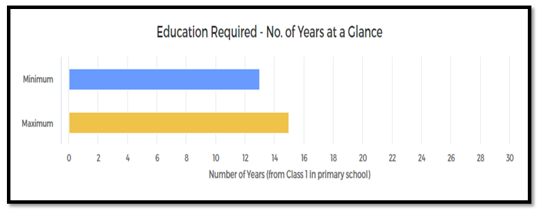
MINIMUM EDUCATION REQUIRED | MAXIMUM EDUCATION REQUIRED |
Post Higher Secondary Diploma / Certificate Programs for which the minimum eligibility is a pass in Higher Secondary / Class XII School Leaving examination. | Under Graduate Undergraduate Degree / Honours Diploma / Graduate Diploma (equivalent to a Degree) Programs for which the minimum eligibility is a pass in Higher Secondary / Class XII School Leaving examination. |
COMPETENCIES REQUIRED
1. You should have interests for Investigative Occupations. Investigative occupations involve working with ideas and quite a lot of thinking, often abstract or conceptual thinking. These involve learning about facts and figures; involve the use of data analysis, assessment of situations, decision making and problem-solving.
2. You should have interests for Realistic Occupations. Realistic occupations involve more practical and hands-on activities than paperwork or office work. Realistic occupations often involve physical activities for getting things done using various tools and equipment.
3. You should have interests for Conventional Occupations. Conventional occupations involve repetitive and routine tasks as well as fixed processes or procedures for getting things done. These occupations involve working more with data, systems, and procedures and less with ideas or creativity.
4. You should have knowledge of Computers, Data and Information Security-computer systems, common consumer software, relevant GIS or related software, their benefits and applicability.
5. You should have knowledge of Geography - Knowledge of principles and methods for describing the features of the land, sea, and air masses, including their physical characteristics, locations, interrelationships, and distribution of plant, animal, and human life.
6. You should have knowledge of Mathematics - arithmetic, algebra, geometry and other mathematical disciplines and their applications.
7. You should have Critical Thinking Skills - analysis of complex situations, using logic and reasoning to understand the situations and take appropriate actions or make interpretations and inferences.
8. You should have Problem Solving Skills- analysis and understanding of problems, evaluating various options to solve the problems and using the best option to solve the problems.
9. You should have Active Learning Skills - Focused and continuous learning from various sources of information, observation and otherwise for application in getting work done.
10. You should have Judgment and Decision Making Skills- considering the pros and cons of various decision alternatives; taking appropriate and suitable decisions.
11. You should have Inductive Reasoning Ability- combine pieces of information from various sources, concepts, and theories to form general rules or conclusions. For example, analyzing various events or situations to come out with a set of rules or conclusions.
12. You should have Deductive Reasoning Ability- apply general rules and common logic to specific problems to produce answers that are logical and make sense. For example, understanding the reasons behind an event or a situation using general rules and common logic.
13. You should have written Comprehension Ability- read and understand information and ideas presented in writing.
14. You should have information Ordering Ability- arrange things or actions in a certain order or pattern according to a specific rule or set of rules (e.g., patterns of numbers, letters, words, pictures, mathematical operations).
15. You should have Perceptual Speed- quickly and accurately compare similarities and differences among sets of letters, numbers, objects, pictures, or patterns. The things to be compared may be presented at the same time or one after the other. This ability also includes comparing a presented object with a remembered object.
16. You always or mostly prefer to stick within a routine or carry out routine and repetitive activities.
17. You are always or mostly organized in your day-to-day life and activities.
Career - Job Opportunities & Profiles
After your training and certification, at the beginning of your career, you can get a job in the Geo informatics industry as a:
1. GIS Trainee
2. GIS Operator
3. GIS Technician
Many IT and IT Enabled Software or services companies such as Capgemini, DSM Soft, etc. will offer you a job. Besides IT and IT Enabled Software or services companies, various companies involved in the business of preparing maps, GIS software, etc. may also offer you jobs.


CAREER GROWTH
If you begin as a Geo-informatics Assistant / GIS Technician, you may progress as GIS Trainee, GIS Technician, GIS Operator, GIS Executive, GIS Analyst, GIS Specialist, GIS Expert, GIS Manager, GIS Operations Manager. Remember that for the mid-level and senior positions, you will need Bachelors’ degrees and professional certificates.
Salary Offered
1. Salaries vary according to job profiles and the kind of facilities you get to work at.
2. In the entry-level jobs: You may expect to get about Rs.10, 000 – 12,000 per month.
3. Salaries increase with your work experience and as you get promoted.
4. In the mid-level jobs, with 5-8 years of work experience, you may expect to get about INR 30,000 – INR 35,000 per month.
5. In the senior level jobs with 10-15 years of work experience, you may expect to get about Rs. 50,000 – 70,000 or even more per month.
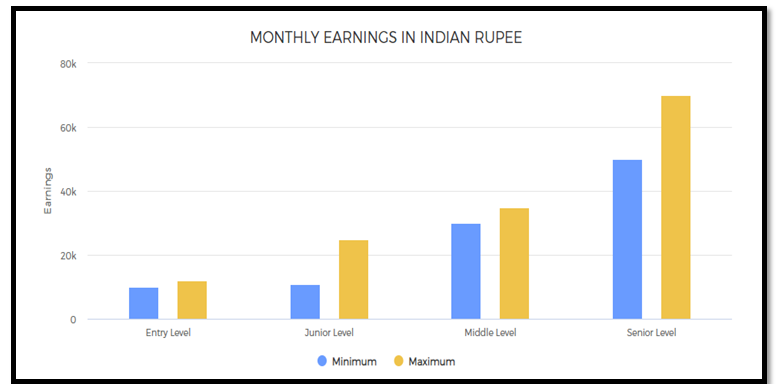
MONTHLY EARNINGS IN INDIAN RUPEE
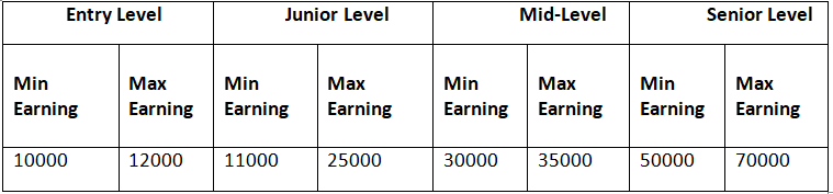
1. Entry level: 0 - 2 years of work experience
2. Junior Level: From 1 to 12 years of work experience
3. Mid-Level: From 5 to 20+ years of work experience
4. Senior Level: From 10 to 25+ years of work experience (there could be exceptions in some high-end technical, financial, engineering, creative, management, sports, and other careers; also in the near future, people will reach these levels much faster in many careers and in some careers, these levels will have no meaning as those careers will be completely tech skill driven such as even now, there is almost no level in a Cyber Security Expert’s job)
Work Activities
As a Geo-informatics Assistant / GIS Technician, you will be:
1. Using computers for work - Using computers for day-to-day office work; using computer software for various applications in day-to-day professional work; entering data and process information; for writing.
2. Analyzing and interpreting data and information - Analysis of data and information to find facts, trends, reasons behind situations, etc.; interpretation of data to aid in decision making.
3. Processing information - Searching, compiling, tabulating, calculating, auditing, verifying or otherwise dealing with information processing including data entry, transcription, recording, storing and maintaining databases.
4. Getting Information and learning - Observing, hearing, reading, using computers, or otherwise obtaining information and learning from it.
5. Updating and using relevant knowledge - Keeping updated with the latest knowledge relevant to your fields of work and use of the relevant knowledge in getting things done.
6. Creative thinking - Developing new ideas, concepts, innovative solutions to problems, newer ways of getting things done, designing products and services, creating work of art and craft, etc.
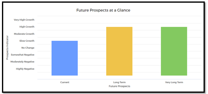
Future Prospects
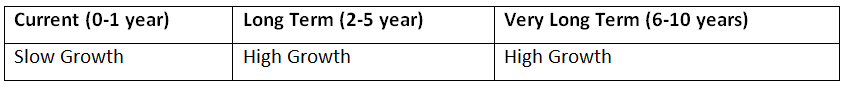
The future of Geo-informatics Assistant / GIS Technicians seems bright. The net Geospatial Intelligence, Mapping, and Analytics Industry has grown from Rs 5000 crores . There are huge employment opportunities in India for basic services like surveying, content development, map digitization, data analytics, APIs etc. This industry has also provided a significant trade surplus of more than Rs. 5000 crores , contributing negatively to India’s huge fiscal deficit.
Geospatial Services Exports is aimed to grow from Rs. 6000 crores to Rs. 39,000 crores by FY 2027-28. India is expecting 1 million more jobs to be generated in this sector through direct and indirect hires by FY 2027-28.
FUTURE PROSPECTS AT A GLANCE